


Integrated Assessment for Integrated Water Resources Management
Overview
The watershed’s water resources consist of surface water and groundwater in aggregate. Historically, dam construction is considered to be part of surface water resources, and well use in basins and other areas is considered to be part of groundwater resources, but the relationship between groundwater produced by infiltration of rainfall and rivers supported by groundwater discharge cannot be clearly separated in terms of the water cycle.
The Basic Law on Water Circulation, which entered into effect in July 2014, enshrines the integrated management of surface and groundwater in the basin, taking into account the public nature of water, and the maintenance of the sustainability of the water cycle. A large watershed includes several municipalities, and watershed councils are established and activities are carried out. In particular, groundwater is regarded as public water and must in future bear costs and environmental protection measures appropriate for large-scale use by enterprises and other organizations. In addition, it was stressed that integrated use of groundwater resources to supplement surface waters is necessary during future droughts (a decrease in surface water, which is generally considered as a decrease in the level of dams and lakes).
Example
Surface and groundwater flow in Mt. Aso and Kumamoto City
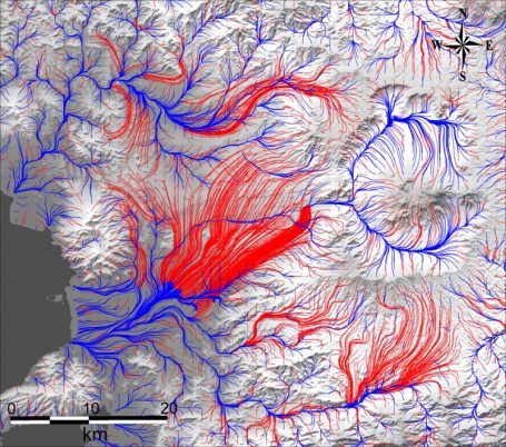 GETFLOWS is based on a fully coupled analysis of surface water and groundwater, which enables us to constantly track the movements of water and to provide scientific information for the integrated management of the watershed. The total amount of natural, dammed lakes and river water, the amount of water stored in groundwater aquifers (pore volume of strata), and the amount of water that can be pumped (pumpable water considering permeability) are estimated as water resources. As an example, we covered the area from Aso to Kumamoto City with a grid and constructed a basin model based on information of topography, geology, land use, etc., and simulated the global river and groundwater flow system with annual average rainfall. By visualizing the lines of river connections (blue) and projected groundwater flows (red) on a flat surface, it is possible to understand the local flow system and to consider specific countermeasures.
Related information
Achievements: Development of a water circulation model for Hadano City’s water resource management and support for information disclosure
GETFLOWS: Features
Technical document: Groundwater Resource Management Using Integrated Geosphere Water Circulation Model (PDF)